Hiking Mount Teide: Routes, Difficulty and What It's Really Like
There are two ways to stand on the highest point in Spain: ride the cable car to 3,555 m and walk the short summit path, or climb every metre from the Montaña Blanca car park yourself. I did it the hard way in July 2026 — starting at midnight, summiting for sunrise — and this guide is what I wish I’d read first: the real numbers, the permit-and-fee system that changed again in January 2026, and the walks worth doing even if you never go near the top.
The classic ascent: Montaña Blanca to the summit
The standard on-foot route stitches together two numbered park trails. Trail 7 (Montaña Blanca–La Rambleta) starts from a lay-by car park on the TF-21 at km 40.2, at roughly 2,350 m. Trail 10 (Telesforo Bravo) takes over at the top cable-car station and delivers you to the crater rim at 3,715 m. All in, it’s a little over 8 km of trail to La Rambleta plus the short summit path — call it 9 km and around 1,370 m of ascent one way. Most reasonably fit walkers take 5–7 hours up and 3–4 hours back down.
The character of the route changes three times:
- Km 0–4: the track. A broad 4x4 track climbs gently across pale pumice slopes towards the hump of Montaña Blanca itself. You’ll pass the Huevos del Teide — house-sized black lava boulders that rolled down the mountain and set where they stopped. Easy walking; deceptive, because you’re gaining altitude without noticing.
- Km 4–6.5: the zigzags. At about 2,750 m the track ends and the real climbing starts. Tight switchbacks on loose pumice and scree, relentlessly steep, up to the Refugio de Altavista at 3,260 m. This is where most people slow to a crawl — two-thirds of the effort lives in this stretch and the one after it.
- Km 6.5–8.3: the lava. Above the refuge the path crosses darker, blockier lava to La Rambleta at 3,555 m, where it meets the cable-car crowds. From there trail 10 is a further 600-odd metres of engineered path and about 160 m of climb to the rim — short, but at that altitude every step is a small negotiation.
There’s no scrambling and nothing technical anywhere on the route. The difficulty is purely gradient plus thin air, which is exactly what makes it easy to underestimate.
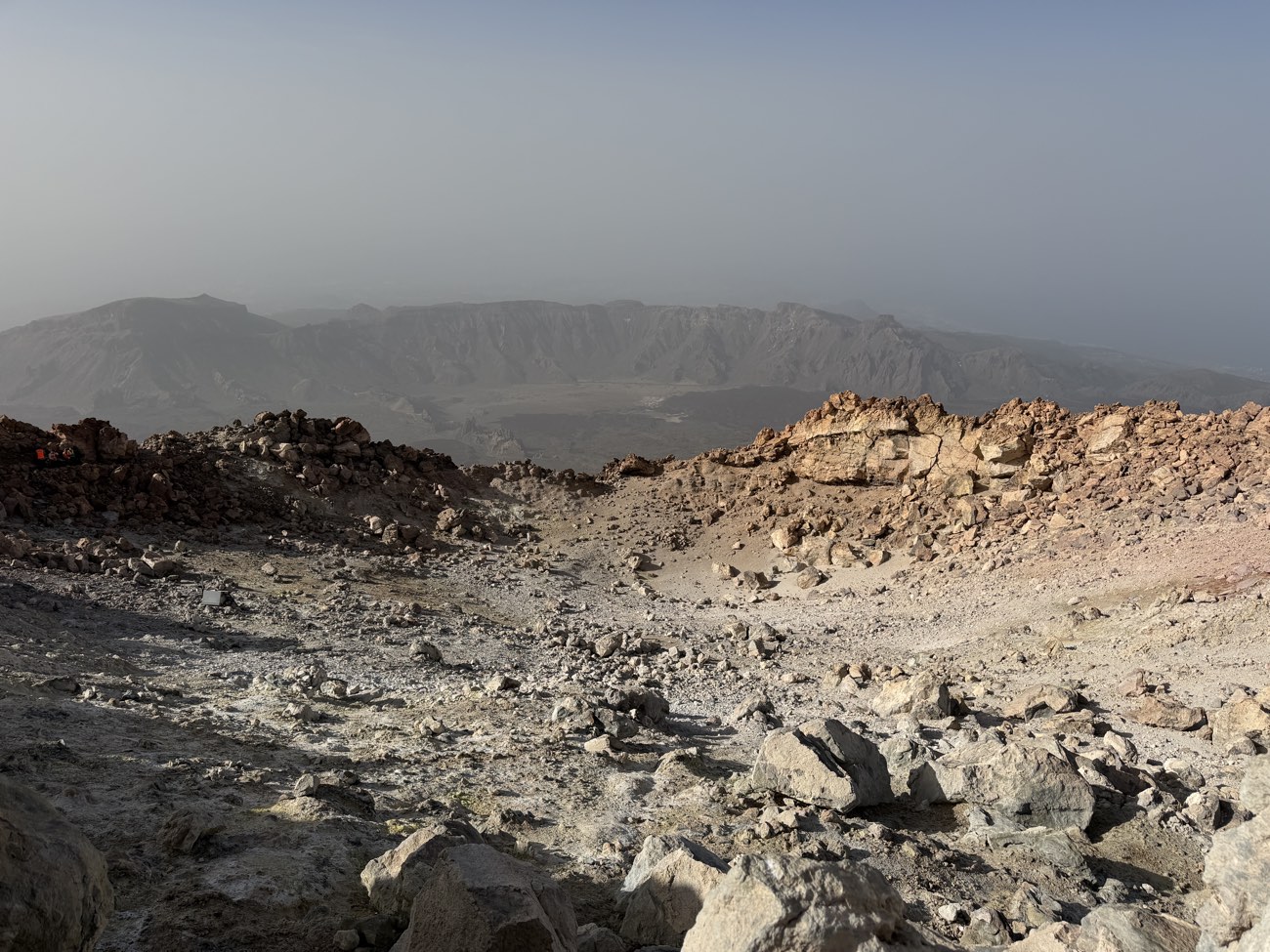 The crater rim at 3,715 m: sulphur-stained rock and warm fumarole vents — the smell tells you the volcano is dormant, not dead.
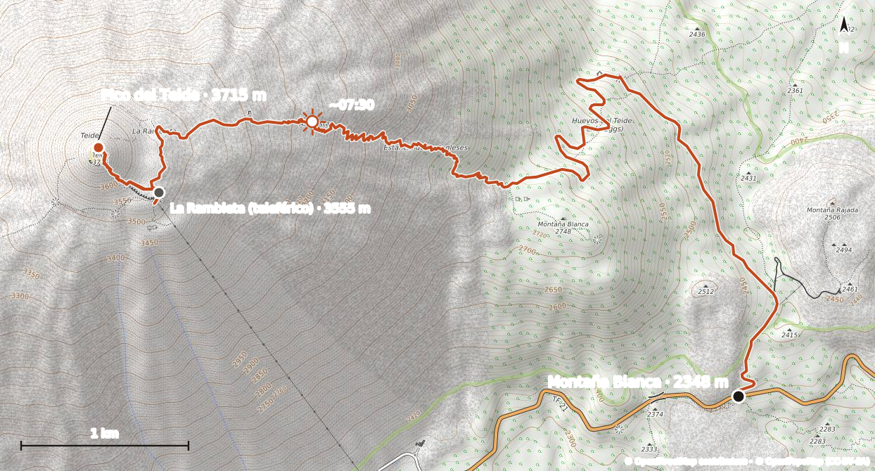 The route as we recorded it — from the Montaña Blanca car park up to the crater and down to the La Rambleta cable car station.
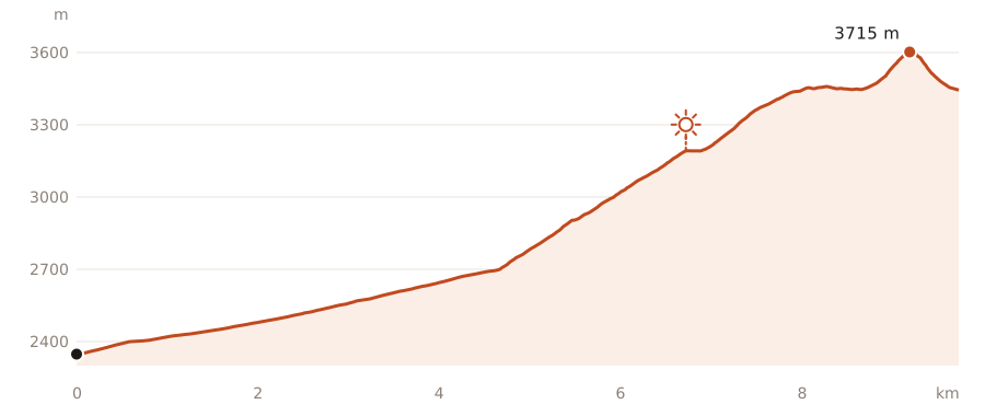 The recorded elevation profile — a relentless 1,300 m of climbing with barely a flat metre. The sun marks where sunrise caught us.
Planning this hike? Download our GPX track from July 2026 and load it into your navigation app: teide-montana-blanca.gpx.
Permits and fees: what changed in 2026
This is where most older guides will mislead you. Not long ago, only the final summit path needed a (free) permit, booked through the Spanish national parks site. The rules then changed in stages: trail 7 Montaña Blanca has needed a reservation since late November 2024, summit-path bookings moved to the island’s own Tenerife ON platform for climbs from September 2025, and since 19 January 2026 a fee — the ecotasa — applies to non-residents in the busiest hours. If you’ve found instructions pointing at reservasparquesnacionales.es, they’re out of date.
The fees, introduced on 19 January 2026:
| Trail and charged hours | Tenerife residents | Other Canary residents | Everyone else |
|---|---|---|---|
| Trail 10 Telesforo Bravo, 09:00–17:00 | Free | €6 | €15 |
| Trail 7 Montaña Blanca, 09:00–15:00 (weekdays) | Free | €3 | €6 |
| Trail 7 Montaña Blanca, 09:00–15:00 (weekends, holidays) | Free | €5 | €10 |
Children under 14 go free on all of it, and slightly reduced rates apply on some guided visits. Outside the charged windows a reservation is still required, but — as the system stood in July 2026 — it costs nothing, which is one more argument for the pre-dawn start.
The practical details that actually bite:
- Slots are released every Monday at 07:00 Canary time. Since 16 March 2026 all five regulated trails — the summit path included — work on a rolling 56-day window, doubled from the previous 28 days. Sunrise slots for the summit vanish fastest — set an alarm.
- Daily numbers on the summit path are capped (around 200 places at the time of writing, split into timed slots from pre-dawn to evening). The permit is nominal: carry the ID you booked with, because it gets checked.
- Confirmed bookings can’t be changed, transferred or refunded, with exceptions only for weather closures of the trail or the cable car.
- A handful of other high routes (trails 9, 23 and 28) also need authorisation — relevant if you fancy the Pico Viejo side of the mountain.
If the Monday scramble fails, the standard workaround still works: guided ascents come with the operator’s own permit allocation, and you can compare the options on our tours page. The full booking walkthrough, screenshots and fallback plans live in the summit permit guide.
One honest caveat: Tenerife has rewritten Teide access rules several times between 2024 and 2026, and the ecotasa was only months old when I wrote this. Check Tenerife ON for the current state before you plan around any figure here.
Climbing in the dark: the pre-dawn start
I left the Montaña Blanca car park a little after midnight. July, no wind, about 12°C — t-shirt weather for the first hour, then progressively less so. By the zigzags I could see a broken line of red headlamps strung up the mountain above me: morale-boosting (you’re not alone) and mildly horrifying (that’s how much higher it goes).
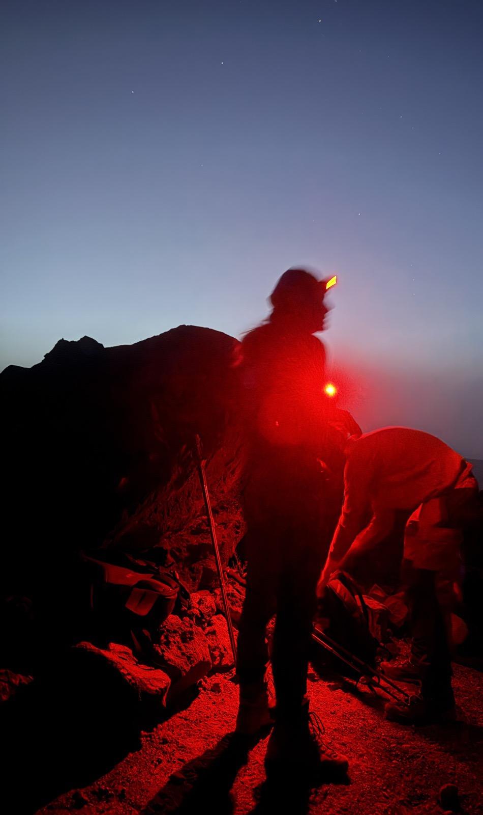 The night shift on the Montaña Blanca zigzags. Red light preserves your night vision — and everyone else’s.
Navigation at night is more straightforward than you’d expect: the first 4 km is an unmissable track, and the upper path is well-worn and marked. A decent headlamp with spare batteries is non-negotiable, and an offline map (the route has no junctions to speak of, but fog does happen). The sky is the compensation — the park is a certified Starlight destination, and at 3,000 m with no moon the Milky Way is genuinely bright enough to walk by.
The timing that worked: midnight start, La Rambleta around 05:30, crater rim just before 07:00, sunrise a few minutes past seven. It was barely above freezing on the rim with a stiff breeze — in July — and everyone who’d carried a down jacket was wearing it. Then the sun came up over a sea of clouds, and the pyramid-shaped shadow of the mountain stretched across the whole island behind us. More on timings and vantage points in the sunrise and sunset guide.
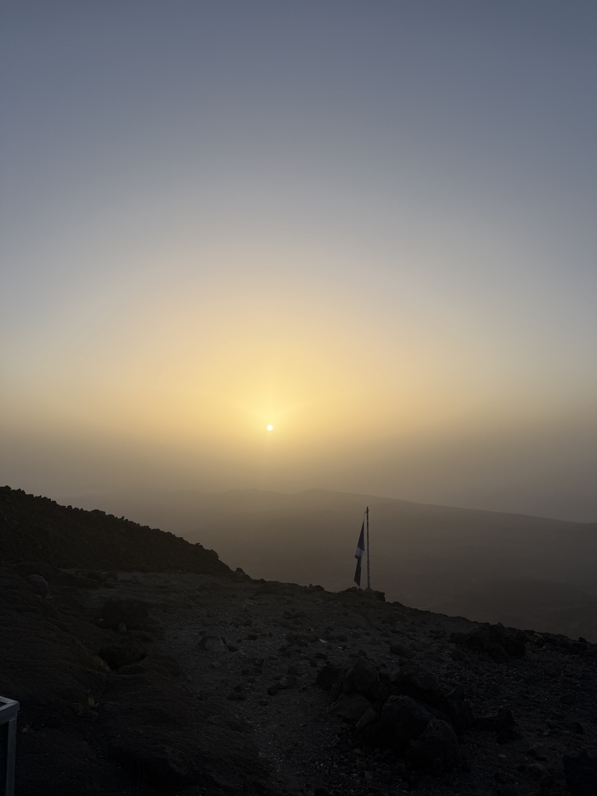 First light on the summit path. The reward for six hours of climbing in the dark.
Altitude: how 3,715 m actually feels
At the summit there’s roughly 40% less oxygen than at sea level. Most people feel it somewhere above 3,000 m: a light headache, breathlessness out of proportion to effort, mild nausea, a strange reluctance to eat. That’s normal. What matters is pace — above 3,000 m, gaining 300 vertical metres an hour is a perfectly respectable speed, and trying to hold your sea-level pace is the single most common way people wreck their own summit day.
Things that genuinely help: drink more than feels necessary (the air is bone dry), eat small amounts often, and don’t sprint the zigzags. Walkers who climb from the bottom usually cope better than cable-car passengers, who go from 2,356 m to 3,555 m in eight minutes with zero acclimatisation — the six-hour climb is its own adjustment period.
If a headache becomes severe, or you’re dizzy, vomiting or confused, the fix is always the same: go down. Anyone with significant heart or lung conditions, and pregnant women, are officially advised against the top section — if in doubt, ask your doctor, not the internet.
Getting down: cable car or your knees
You don’t have to walk back. Hikers who come up trail 7 can buy a descent-only cable-car ticket at the upper station — it’s sold on the spot via QR code at La Rambleta, not pre-bookable, and only when the cable car is actually running. In 2026 a one-way ride costs €23.50 for a non-resident adult (€11.75 for children) against €42 for a standard return; current figures are on the official price page.
Two catches. First, hours: in high summer (1 July–30 September) the last descent is 18:30, but for most of the year it’s 16:50 — miss it and you’re walking. Second, wind: the cable car shuts in strong wind at short notice, so a descent ticket is a convenience, never a plan. Budget the legs and daylight to walk down regardless. The descent takes 3–4 hours and the pumice sections are genuinely punishing on knees; poles earn their weight here more than anywhere. The full rundown of tickets, queues and closures is in the cable car guide.
Refugio de Altavista: reopened in 2026
For years the obvious way to split the climb — sleep at the Refugio de Altavista at 3,260 m, summit at dawn — simply didn’t exist, because the refuge had been shut since the pandemic. That finally changed in summer 2026: after a multi-million-euro refurbishment, the Cabildo handed operation to the cable-car company and the refuge reopened in July 2026 with 49 bunks, an infirmary, solar power and the original guest book that’s been signed since 1929.
An overnight there transforms the climb: you do the brutal middle third with fresh legs in daylight, sleep (badly — it’s 3,260 m) and stroll to the rim for sunrise. Historically, refuge guests could summit before 09:00 without a separate trail 10 permit; the reopening is so recent that you should confirm how bookings, prices and summit access now work when you book, rather than trusting any guide written months earlier — this one included.
The best walks that aren’t the summit
Teide National Park has more than 40 numbered trails, and some of the best walking involves no permit, no alarm clock and no headache. Four I’d actually recommend:
Roques de García (trail 3). The famous one — a 3.6 km loop from the Mirador de La Ruleta by the Parador, around the eroded rock towers that include Roque Cinchado of old 1,000-peseta-note fame. The climb back up from the Ucanca plain is the only real effort. Do it at golden hour when the coaches have gone.
Alto de Guajara (trails 5 and 15). The classic Teide postcard is taken from Guajara, the 2,715 m high point of the caldera wall. From the Parador, link trail 4 briefly, climb trail 5 to the Degollada de Guajara pass, then trail 15 to the summit — about 11–12 km and 600 m of ascent as a loop, returning via the Degollada de Ucanca on trail 31. On top are the ruins of the hut used by astronomer Jean Mascart to observe Halley’s Comet in 1910, and the single best view of Teide there is.
Samara (trail 13). A 5 km loop from the Mirador de Samara on the TF-38 (km 7.5) through a landscape of black cinder cones, scattered Canary pines and the young lava fields spilling from Pico Viejo — including a view towards Narices del Teide, the vent of the park’s last eruption in 1798. Around 290 m of gentle climbing; two hours well spent.
Arenas Negras (trail 2). A 7.6 km loop from the El Portillo visitor centre over black volcanic sand, along the caldera wall with views back over the whole Las Cañadas amphitheatre — a bowl roughly 16 km across at its widest. About three hours, with one sharp downhill stretch that wants decent footwear.
| Walk | Trail no. | Distance | Ascent | Time | Effort |
|---|---|---|---|---|---|
| Montaña Blanca to the summit | 7 + 10 | ~18 km round trip | ~1,370 m | 8–11 h total | Very hard |
| La Rambleta to the crater (via cable car) | 10 | ~1.2 km return | ~160 m | 45–90 min | Short but breathless |
| Roques de García loop | 3 | 3.6 km | ~150 m | 1.5–2 h | Easy–moderate |
| Alto de Guajara from the Parador | 5 + 15 | ~11–12 km | ~600 m | 4–5 h | Moderate–hard |
| Samara loop | 13 | ~5 km | ~290 m | 2–2.5 h | Easy–moderate |
| Arenas Negras loop | 2 | 7.6 km | ~370 m | ~3 h | Moderate |
Figures are approximate; only trails 7 and 10 (plus 9, 23 and 28) currently need reservations.
A note on transport: public buses do reach the park — Titsa line 342 from Costa Adeje (out 09:25, back from El Portillo 15:15) and line 348 from Puerto de la Cruz (out 09:30, back from the Parador 16:00), one journey per day each way (timetables). That works for Roques de García; it’s useless for a summit day. Driving and other options are covered in getting to Teide.
Safety: the mountain is higher than it looks
People treat Teide as a big hill on a beach holiday. It’s a 3,715 m alpine environment that happens to be a bus ride from sunloungers. The specific hazards:
- No water. Anywhere. There are no springs, taps or kiosks on trails 7 or 10. Carry a minimum of 2 litres per person, 3 in summer. I drank 3.5 on my sunrise climb and finished them.
- Weather swings. A 25°C day at the coast can be 5°C and 60 km/h wind at La Rambleta. Summit windchill goes below freezing in every month of the year.
- Sun. UV at 3,500 m is savage and the pumice reflects it back at you. Factor 50, sunglasses, hat — even, and especially, on the pre-dawn climb, because you’ll descend in full sun.
- Winter conditions are real. Snow and ice regularly close the upper trails between roughly December and March; when they’re icy, people without microspikes get hurt. Check trail status on Tenerife ON before driving up.
- When not to go: strong wind warnings, calima (Saharan dust — visibility and lungs both suffer), fresh snowfall, or any forecast of storms. Seasonal trade-offs are covered in the best time to visit.
Mobile coverage on the mountain is patchy but adequate near the route; 112 is the emergency number, and it works in English.
What to carry
Summer (June–September): 2–3 litres of water, headlamp plus spare batteries for any pre-dawn start, windproof shell, fleece plus a light insulated jacket for the summit, warm hat and gloves (yes, in July), sun hat, factor 50 and sunglasses, boots or sturdy trail shoes with grippy soles for the pumice, poles for the descent, more food than you think, a power bank, offline maps, and the ID you booked your permit with.
Add in winter (roughly November–April): a proper insulated jacket, warm waterproof gloves, gaiters, and microspikes or light crampons you actually know how to use — plus the humility to turn around when the upper mountain is ice.
Frequently asked questions
Do you need a permit to hike Mount Teide?
Yes — and more than before. The summit path (trail 10, Telesforo Bravo) has needed a permit for years, and the Montaña Blanca approach (trail 7) has required a reservation since late November 2024 — both booked on Tenerife ON with new slots released every Monday at 07:00 Canary time. Since 19 January 2026 non-residents also pay a fee in the busiest hours: €15 for the summit path, €6–10 for trail 7. Other park trails, like Roques de García, need nothing.
How hard is the Montaña Blanca route?
It’s a serious mountain day rather than a technical climb: around 1,370 m of ascent over a little more than 8 km, all on trail, with no scrambling. The difficulty comes from the gradient of the middle section and the altitude — above 3,000 m most people slow down noticeably. A reasonably fit hillwalker will manage it in 5–7 hours up; someone who only walks on holiday will find it brutal but usually possible with an early start and a slow pace.
Can you climb Teide for sunrise without staying at the refuge?
Yes — that’s exactly what I did in July 2026. Book trail 7 and a sunrise slot on trail 10 through Tenerife ON, start from the Montaña Blanca car park around midnight, and you’ll reach the crater rim for a seven-o’clock summer sunrise. You need a good headlamp, warm layers and 5–7 hours of steady climbing in the dark. Alternatively, the reopened Refugio de Altavista at 3,260 m lets you split the climb over two days.
How long does the whole hike take?
Budget 5–7 hours from the Montaña Blanca car park to the summit and 3–4 hours back down, so 8–11 hours total on foot. Riding the cable car down from La Rambleta cuts the descent to minutes — a one-way ticket cost €23.50 in 2026, bought at the top station — but the cable car closes in strong wind and outside summer runs only until late afternoon, so never rely on it as your only way off the mountain.
Is there any water on the trail?
No. There are no springs, fountains or shops anywhere on trails 7 or 10, and nothing at the Montaña Blanca car park either. The air at altitude is extremely dry and you lose fluid faster than at sea level, so carry at least 2 litres per person — 3 or more in summer. The nearest reliable water and food are at the cable-car base station and the Parador, both a drive from the trailhead.
What happens if you hike without a permit?
Wardens check permits — against photo ID — at the foot of the Telesforo Bravo path, and Montaña Blanca has had controls since reservations became compulsory there in late 2024. Without a booking you’ll be turned back at La Rambleta, having done all the climbing for none of the summit, and fines are possible. If the Monday release is sold out, a guided ascent with permit included is the reliable fallback.
Is winter a bad time to climb?
Not necessarily — clear winter days offer the best visibility of the year and snow makes the park spectacular. But the upper trails close after snowfall, ice lingers on the shaded zigzags for weeks, and summit windchill is genuinely alpine. If you’re set on a winter ascent, build flexibility into your dates, check trail status on Tenerife ON the day before, and carry microspikes. December to March summit attempts fail to weather far more often than summer ones.